|
|
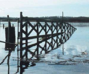
Rising waters cause high tides
to mix with fence posts at Holland Cliffs Shores, Md.
(Photo courtesy NOAA)
|
By Daina Klimanis
Maryland Newsline
Thursday, May 6, 2004
After Hurricane
Isabel flooded Chesapeake Beach, Md., Wesley Stinnetts Restaurant and Bar stood under about 6 feet of water.
The deluge did so much damage that owner Gerald W. Donovan decided
not to reopen the restaurant, which had been in his family since 1936.
Though it was Isabel's high tides that finished the restaurant,
Donovan describes the flood as the decisive clash in a longer battle
between land and tide.
Warming global
temperatures have led sea-water levels to rise a few inches worldwide in
the last century, but water levels in the bay have risen fasterabout a
foot during the last 100 years.
As a result, low-lying
land along the Chesapeake is turning into open water, and other
stretches are coming further into the flood zone.
Chesapeake Bay water
levels have been rising more than 3 millimeters a year on average,
according to more than 60 years of measurements by the National Oceanic
and Atmospheric Administration. This is fast enough to turn marshes into
open water. Its also fast enough to damage waterfronts.
The property is more
prone to flood, Donovan said. Even though its minute, over a 20-,
30-year period, its several inches.
That can be a lot in the flat counties bordering the Chesapeake.
Rising Tides
In some places, land
is going underwater.
One of the most visible examples is in the Blackwater National Wildlife Refuge, a 26,000-acre waterfowl sanctuary
in Dorchester County, where 150 to 400 acres of marshland turn into
mudflats or water every year, according to the conservation department
at the National Aquarium in Baltimore.
Why Chesapeake waters
are rising faster than ocean waters is murky. Court Stevenson, a
professor at the University of Maryland Center of Environmental Science,
and Michael Kearney, an associate geography professor at the University
of Maryland, have hypothesized that the large amount of soil material
washing into the bay is depressing the bay floor, causing shorelines to
sink down relative to water level.
Similar situations
have occurred in states further west, where dams have trapped enough
sediment to sink the floors of the reservoirs, Kearney said.
The effect is
magnified because the bay is so shallow, so a little increase in water
level makes a big difference, Kearney said. The bays average depth is
under 30 feet, according to the University of Maryland Chesapeake
Biological Laboratory.
The bay shore may also
be sinking because people are drawing water from large underground
aquifers underneath, Stevenson said. A study of soil core
samples and historic land survey records led Kearney and Stevenson to
conclude that the bays water level rose dramatically after 1850--which
points to human influence.
Drowning Marshes
The effects on marshes only became apparent after
the 1970s, when Blackwater National Wildlife Refuge personnel asked
scientists to explain extensive marsh loss at the refuge. Stevenson was
one of the scientists who examined the problem.
The land area in that
part of Dorchester County is so flat that it just gets overtopped by
water," said Curt Larsen, a
retired research geologist for the U.S. Geological Survey.
"The
plants basically drown,"
Stevenson said.
Larsen concluded that at current
rates of water rise, most of Blackwater will be gone by 2050. Marsh loss
will only accelerate after that, he said.
Some officials are looking
for ways to save Blackwater and other low-lying areas, a task made more
difficult because the effects of water rise are compounded by other
problems.
Some developed properties
along the bay, including Donovans, are built on former marshland that
is compacting decades after buildings and parking lots were built on top
of it. In Blackwater and other marshes, erosion has been hastened by
large rodents called nutria.
These rodents, which can
reach 20 pounds, invaded the area after being imported from South
America in 1943 to boost the fur trade, according to the Maryland
Department of Natural Resources. Nutria eat away the grasses that keep
marsh sediment in place.
The Nutria Project
Partnership, funded by a congressional grant, is working to solve the
nutria problem. Meanwhile, the Army Corps of Engineers is restoring
eroded marshes with sediment taken from the bays floor during dredging
done to deepen shipping lanes.
| Disappearing Islands
By Daina Klimanis
Maryland Newsline
Thursday, May 6, 2004
Some bay islands have already gone underwater.
Michael Kearney, an associate geography professor at the University of
Maryland,
described the town of Broadwater on Hog Island in the early 1900s: Places where people once lived are hardly above sea level now, and
everyone has moved from that end of the island, he said.
Sharps Island, boasting
schools and a popular resort in the 19th century, is entirely
underwater now.
Remaining Chesapeake island settlements and low-lying Eastern Shore
communities will see a similar fate, he predicted.
Youll
either pick the house up and move up to a higher elevation, or youll
leave the area altogether, he said. Youre going to have potentially a
lot more flooding and storm damage
"By
the mid-century, this is going to be a major issue.
|
When studies determined
traditional methods could not effectively restore Blackwaters marshes,
the Army Corps turned to an experimental technique called thin-layer
spraying, in which acres of marsh were brought above water level with a
few inches of dredge material. Hundreds of volunteers then planted the
new land with marsh grass to stabilize it, said Bev Waggoner, an
organizer from Friends of Blackwater National Wildlife Refuge.
Fifteen acres of the refuges mudflats and open
water have become marsh habitat again, as well as a few acres on Barren
Island, which is south of the Choptank River and also part of the
Blackwater refuge, Wagonner said. Three months after the first grasses
were planted, diamondback terrapins were laying eggs there.
The area looks fabulous now, Waggoner said.
People (once) would be up to their knees or up to their waists in muck
Now the grasses are over our heads.
Restoring the island is an ongoing project.
Volunteers will plant 15 acres more acres of Barren Island in the
summer, and the Army Corps is studying the possibility of restoring the
whole Blackwater refuge, said Steven Kopecky, Army Corps project
manager.
The thousands of acres of work would likely cost in
the tens of millions of dollars, Kopecky said. The 20-acre original
project cost $450,000.
Even then, the result
might be only temporary. Orrin
Pilkey, director of the Program for the Study of Developed Shorelines at
Duke University, said rising sea levels just submerge the
restoration work in future decades.
"Youre going to do it
again and again," Pilkey said.
A Forecast of
Floods
Public interest in
sea-level rise is growing, Kearney said.
Isabel was sort of a
wake-up call last September, he said. People began imagining, if this is what Isabel
could do, what if a Category 3 or, God forbid, a Category 5 hit us?
Category 5 storms have
winds over 156 mph. Isabel was a Category 2 storm as it made landfall in
North Carolina, with winds between 96 and 110 mph, according to the
National Oceanic and Atmospheric Administration. Around the time it
passed into Maryland, Isabel was downgraded to a tropical storm, with
winds between 39 to 73 mph.
But the sea level rise that concerns academics or owners of
waterfront property is not something most people are talking about, even
in many towns bordering the bay.
Bruce Wahl is a council member at Chesapeake Beach in Calvert County,
the same town where Stinnett's restaurant was closed by Isabel. But he
said he's not aware of the way water rise contributed to the problem.
Ive lived here for 18 years, and I suspect theres been some rise,
but I really dont know much more than that, Wahl said. I think if
scientifically we can prove the water levels going to rise a certain
number of inches
it would be a concern, but I also think its obvious
we wouldnt be able to do anything about that.
Cities on shores across the world are using
technological means like tide gates to limit the effects of sea-level
rise, Stevenson said. However, the sprawling geography of the Chesapeake
Bay wont allow for such a comprehensive solution.
Bulkheads are another option, Kearney said, but
they can cost hundreds of dollars a foot.
Instead, around the Chesapeake Bay, many are just
doing what Donovan did after floods damaged Wesley Stinnetts Restaurant
and Bar.
Donovan just closed up and focused on the restaurants he
owned that were further above the waterline.
|